Navigating the open waters requires precision, reliability, and efficiency. Marine navigation systems have evolved significantly over the years, incorporating cutting-edge technology to enhance safety and accuracy. Whether you are a recreational boater, a commercial mariner, or a deep-sea explorer, understanding marine navigation systems is essential for a successful voyage. This guide will explore the different types of marine navigation systems, their benefits, and how to choose the right one for your needs.
Types of Marine Navigation Systems
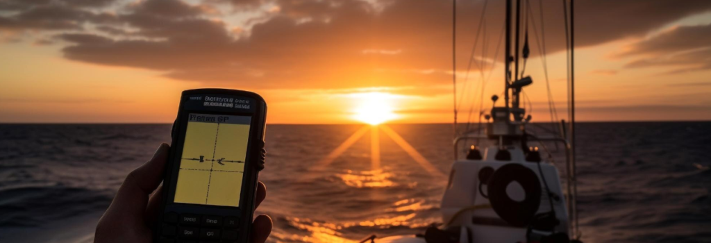
1. GPS (Global Positioning System)
The Global Positioning System (GPS) is one of the most widely used navigation tools for marine applications. It provides real-time location tracking and route planning by utilizing a network of satellites. GPS systems are highly accurate and can operate in almost all weather conditions. Many modern marine GPS devices come with additional features like chart plotting, waypoints, and integration with other navigation tools.
2. Radar Systems
Radar (Radio Detection and Ranging) is an essential navigation tool used to detect objects, landmasses, and other vessels, especially in low-visibility conditions. Marine radar systems use radio waves to map the surrounding environment, helping mariners avoid collisions and navigate safely through fog, rain, or darkness. They are particularly useful for commercial and military vessels that operate in busy waterways.
3. Electronic Chart Display and Information Systems (ECDIS)
ECDIS is a digital alternative to traditional paper charts, offering advanced mapping and navigational features. These systems integrate GPS data with detailed electronic navigational charts (ENCs), providing real-time positioning and route planning capabilities. ECDIS is mandatory for large commercial vessels and enhances efficiency by reducing the need for manual chart updates.
4. Automatic Identification System (AIS)
AIS is a tracking system used to enhance vessel-to-vessel and vessel-to-shore communication. It provides information about a ship’s position, speed, and course, allowing other vessels to anticipate its movements and avoid collisions. AIS is especially useful in congested waterways and for monitoring maritime traffic in busy ports.
5. Depth Sounders and Sonar Systems
Depth sounders and sonar (Sound Navigation and Ranging) systems are used to measure water depth and detect underwater obstacles. These systems use sound waves to map the seafloor and identify hazards such as rocks, wrecks, and submerged structures. Sonar technology is widely used in commercial fishing, research, and naval operations.
6. Compass and Gyrocompass
Traditional magnetic compasses and modern gyrocompasses are essential tools for navigation. A magnetic compass relies on the Earth’s magnetic field to indicate direction, while a gyrocompass uses a spinning gyroscope to provide accurate heading information. Gyrocompasses are more stable and reliable, making them the preferred choice for larger vessels and commercial ships.
7. Loran-C (Long Range Navigation)
Although less common today due to the widespread use of GPS, Loran-C is a terrestrial navigation system that uses radio signals from fixed stations to determine a vessel’s position. It serves as a backup navigation tool in case of GPS failure.
Benefits of Marine Navigation Systems
1. Improved Safety
Advanced navigation systems significantly enhance maritime safety by providing accurate positioning, real-time weather updates, and collision avoidance mechanisms. Systems like AIS and radar help vessels detect nearby ships and obstacles, reducing the risk of accidents.
2. Enhanced Efficiency
Navigation systems streamline route planning and optimize fuel consumption, resulting in cost savings for commercial operators. ECDIS and GPS-based chart plotting systems allow mariners to plan efficient routes, avoiding unnecessary detours and delays.
3. Better Environmental Protection
With precise navigation, vessels can avoid ecologically sensitive areas, reducing the impact on marine life and ecosystems. Technologies like sonar help identify and prevent damage to underwater habitats.
4. Increased Autonomy
Modern navigation systems facilitate autonomous and remote-controlled vessel operations. With advancements in artificial intelligence and automation, ships can now operate with minimal human intervention while maintaining high levels of safety and precision.
Choosing the Right Marine Navigation System
1. Vessel Type and Usage
The choice of navigation system depends on the type of vessel and its intended use. For example, commercial ships require advanced systems like ECDIS and AIS, while recreational boaters may only need a basic GPS system.
2. Integration Capabilities
Many modern navigation systems are designed to work together, offering a comprehensive solution for marine navigation. Choosing a system that integrates with existing equipment can enhance functionality and reduce the need for additional hardware.
3. Budget and Cost Considerations
Marine navigation equipment can vary significantly in price. While professional-grade systems may be expensive, they offer superior reliability and features. It is important to balance budget constraints with the required level of functionality.
4. Compliance with Regulations
Certain types of vessels, particularly commercial ships, are required to comply with international maritime regulations regarding navigation equipment. Ensuring that your system meets regulatory standards is crucial for legal operation.
5. Reliability and Durability
Since marine environments can be harsh, choosing navigation equipment that is water-resistant, shockproof, and built for durability ensures long-term reliability and reduces maintenance costs.
Conclusion
Marine navigation systems play a critical role in ensuring safe and efficient voyages. From GPS and radar to ECDIS and AIS, modern navigation tools provide mariners with accurate positioning, route planning, and hazard detection capabilities. By selecting the right navigation system based on vessel type, integration needs, budget, and regulatory requirements, mariners can enhance their navigation experience while prioritizing safety and efficiency on the water.